Attribution
Next month will be twenty-four years since I first climbed the north face of Athabasca. There are far bigger and harder ice faces in the Rockies, but that particular shield of snow and ice, capped by a layered cake of rotten limestone, has got to be the most classic. The glacier-draped north aspect of the peak adorns countless postcards, but the view of it driving south on the Parkway is no less sublime for that.
Erol Altay, with whom I took some of my first steps on vertical ice in the city-park like surroundings of Starved Rock two hours west of Chicago, had flown west for a couple of weeks. We kicked off his trip in rock shoes on Yamnuska, changed into crampons for the Ice Bulge on the north face of Fay, then headed up the Parkway intent on Athabasca. Back in 1995 Rockies’ ice faces were still a reasonable proposition in August, not the ugly, scarred things they tend to become by late summer these days.
Plastic boots and Footfangs on our feet, Pulsars in our hands, we kicked steps up the face. In those distant days mixed climbing hadn’t yet entered our vocabulary. Luckily, the choss band was breached by a ribbon of white ice. We swung and frontpointed up the nearly vertical step, and soon afterwards were balancing along the airy summit ridge. On the descent, in places we butt-slid down summer névé, giggling like kids. Now it all seems like another lifetime. And in a way it was: three years ago a broken hold on Assiniboine cut Erol’s short. Sometimes I still catch myself wondering what we’ll talk about next time we meet.
Erol walks up the glacier toward the north face...
... and kicks his way up towards the well-iced crux.
The Silvehorn seracs, more benign a quarter-century ago.
A psyched Erol dodges the crowds on the summit ridge.
***
Over the years since, I’ve climbed Athabasca’s north face many times: sometimes when bigger ambitions were thwarted, sometimes as a link in a longer chain, and sometimes just to spend time in the mountains with a friend. On the most recent occasion, Seth Keena and I drove up the Parkway with vague plans for a linkup. Later in the day the May sun would climb high in the sky and turn the snow to isothermal mush, but in the morning the crust still held strong, our boots barely denting the frozen surface.
The glacial cwm below the face was littered with ice blocks, disgorged from the creaky seracs a few hundred metres higher. Hmm, I didn’t remember the ice cliffs on the Silverhorn being that active… As fast as the now powdery snow would allow, we postholed through the danger zone. Crossing the bergschrund was an exercise in levitating over more unconsolidated snow, but soon we were wishing for snow as we crabbed up hard alpine ice.
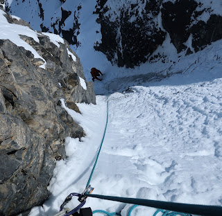
Unroped, we picked separate lines up the lower face to avoid dropping missiles on one another. Where the glassy ice steepened as it squeezed between rock bulges, we roped up. As I climbed up and left, the ice sheet grew thinner and thinner until it petered out altogether. Slowly, I balanced up loose limestone steps welded together by frost. The belay was three so-so pins. Half of the next pitch was more of the same insecure scrambling, capped by a bodylength of near vertical drytooling. Was this where, nearly a quarter-century earlier, I’d twisted in screws and swung into thick ice? It must’ve been, but in the intervening years the route had changed almost beyond recognition. A symptom of global heating?
Seth walks up firm snow on the approach glacier...
... and crosses the cwm to the foot of the north face.
Once on the face, I try to flatfoot to keep the calves from screaming. Photo: Seth Keena.
Seth plugs away at the hard alpine ice.
The Silverhorn seracs, rather more broken up these days.
Where once there was ice over choss, now there's just choss. Photo: Seth Keena.
***
How can we tell if this retreating glacier or that temperature record is due to human-made climate change? The science of attribution tries to answer such questions. Think of rolling a weighted die. Is rolling a 6 caused by the die being weighted? Not exactly; after all, we can roll a 6 with a fair die too. But the die being weighted makes it more likely that, on any given roll, it’ll come up 6.
If all we had was statistics, that might not be too convincing. But we have a lot more: particular causes have particular effects, fingerprints if you will. If global heating was due to the Sun brightening, we’d expect all of the atmosphere to warm. On the other hand, if it was caused by more greenhouse gases being spewed out, we’d expect the lower atmosphere to warm but the upper one to cool. Can you guess which it is?
The first time I climbed the north face of Athabasca, atmospheric carbon dioxide levels were around 360 parts per million. During the most recent climb, they stood at 415. At the rate we’re emitting the stuff, in another quarter century they might reach 600. If I’m still around and climbing, I wonder what the north face will look like then.
***
When Seth joined me at a sunny stance in a small brèche, his right arm didn’t seem to be working too well. An errant stone had scored a direct hit as he belayed me up the loose rubble where once there was ice. As the main objective was to have fun, we nixed our plans for a linkup. We took in a summit panorama that included Bryce, Columbia and Alberta, Rockies’ giants you can’t see from any highway*. Then we hurried down, before the slopes below AA Col turned avalanche-prone in the heat. We stopped in the hanging valley beneath the northeast face of Andromeda to strip off layers, and eat and drink the rest of our food and water. Sitting on our packs, we took in the silence of a brilliant, windless afternoon.
An hour later, we walked down the dirt road beside the Athabasca Glacier as massive snowcoaches rumbled past, enveloping us in clouds of dust and diesel fumes. Maybe there was a moral in the juxtaposition of mountains and industry, but just then I was becoming painfully aware of hot spots on my feet, and it escaped me.
Seth climbs out of the shadowed depths of the face into May sunshine...
... and swings through to take us to the summit ridge.
Seth walks up the last few steps to the meringue-like summit.
On the skyline, from left to right: Columbia, King Edward, Snowdome, the Twins, Kitchener, Alberta, Woolley, Diadem.
* Actually, if you know the right spot, you can see the north face of Alberta from Jasper.


Comments
Post a Comment