Farewell to fall
Jon and I left the city on Friday afternoon, escaping for the Thanksgiving long weekend along with thousands of others. The Rockies stretched across the western horizon under a pale autumn sky. It was already two weeks past equinox, and there was a sharpness to the air that told of changing seasons. Two weeks earlier I’d hiked into the Emperor Face in shorts; now I hurriedly pulled on long underwear as we packed for the coming days in a gravel parking lot beside the Icefields Parkway. The sun had already disappeared behind the summit of Howse Peak, and any illusion of warmth fled along with it. It was a relief to be done with the finger-numbing packing and cooking, and to crawl into the back of Jon’s van for a few hours’ sleep.
We were up long before dawn. Muesli, a thick slice of banana bread, a shot of stovetop espresso, and we were off up the trail, stumbling over roots and crunching through frozen puddles. At Chephren Lake the broad hiking path gave way to an intermittent climbers’ track along the shore, and then even that petered out in a rockslide of quartzite slippery with frost. By the time we stopped to refill our bottles from a glacial stream on the far side of the lake, it was light enough to see without headlamps. The east face of Howse Peak towered above us, blocking out nearly half the sky. Gray ice dripped down it in long, tantalizing streaks. But, having tried the ice on Thanksgiving weekend five years before, we weren’t fooled into thinking it was in shape. Instead, we made across moraine and glacier toward the northeast buttress.
We’d originally planned to go for the north face, but now that we could see into The Gash we weren’t so sure. Almost devoid of ice, the deep slanting gully promised tenuous scratching up compact rock thinly powdered in snow. After weighing our options for a few minutes, we decided to abandon our hardcore ambitions and to continue up the ridge instead. It didn’t help that we hadn’t exactly run up the last few pitches, and they were still supposed to be trade-route terrain. Compared to rock climbing, alpine drytooling is a slow business: dig for tool and gear placements and carefully balance on frontpoints, whereas if the rock were dry you’d just grab, smear and go.
A few more ropelengths of this kind of fun, made even more amusing by overnight packs, and daylight began to fade. Fortunately a wind scoop under an overhanging wall presented itself just in time. We set up a hand line to keep ourselves from falling off the mountain and went to work digging a ledge for our little tent. I never cease to be amazed at the difference even such a fragile shelter can make. Outside, as night fell, spindrift poured down at regular intervals. Inside, all we could hear was gentle pattering on the brightly coloured fabric as we reclined in our sleeping bags, ate freeze-dried curry, and eventually drifted off to sleep.
Getting going after a bivy, even one as comfortable as ours was, is always a test of alpine-climbing mettle: abandoning the body-warmed confines of the sleeping bag, pulling on cold boots, then stepping outside and packing up, all the while getting periodically doused by spindrift. It was a relief to finally rack up and lead out over black ice and snow-covered choss toward the skyline. A couple of pitches that’d been blown clear of snow had us putting rubber and even bare skin to stone, but then it was back to crampons and tools. The climbing itself was rather fine: never desperate but always interesting, with airy traverses, rimed-up chimneys and even the occasional welcome bit of neve. After a few hours in the shade, it was a joy to pop out into bright sunshine on the big ledge running across the whole mountain.
In keeping with our climb-whatever-looks-best approach, instead of following the summer route up the ridge we traversed into the deep gully splitting the upper east face. The guidebook calls it ugly and it might be that in July, but by October it’s an attractive snow couloir, with just enough ice to disqualify it as a ski run (and it’s always embarrassing to climb up one). After the slow going lower down it was liberating to move together, kicking into snow pounded hard by spindrift and swinging into freshly formed ice. Eventually the cornice capping the couloir came into view. I’d been thinking about it for the past hour, wondering if the mountain would throw one last obstacle in our way; as I was beginning to feel tired, I was rather hoping it wouldn’t. But the mountain was kind to us, and we were able to sneak by the overhanging snow and ice on the right.
Having spent the last few hours in a canyon-like gully, it wasn’t until we topped out on the summit ridge that we realized the weather had changed for the worse and our peak was enveloped in cloud. Still, it couldn’t be all that bad, since every once in a while the mists would part and reveal the headwaters of the Howse River, and once or twice even the distant Bugaboos. Nightfall found us pitching our little tent in the lee of a big boulder at treeline. Flat ground and running water: this wasn’t bivying anymore – this was camping.
It rained hard during the night, and it being October we woke to fresh snow not far above camp. Our third day started with a scree slog up to the White Pyramid-Epaulette col. The col itself was whited out, and with the gaping crevasses we could glimpse on the far side, we thought getting down might prove exciting. In the end, though, the worst part of the descent turned out to be the endless rubble on the moraines below the rather diminutive glacier. The last obstacle to be overcome, already within earshot of the road, was the Mistaya River. We didn’t even bother removing our boots, but strode fully dressed into the water. Sadly, given our sodden state, even with the holiday traffic it took us close to an hour to catch a ride back to the van.
The following week it snowed far below treeline all the way out to the foothills. With the mountains this snowy and the days this short, it was time to forget about big alpine adventures, at least for a while. But fortunately, as temperatures dip and water dripping down gray limestone turns to ice, it won’t be hard to find other adventures closer to home. And soon enough, the days will start growing longer again.
Summary: An ascent of
the lower Northeast Buttress to the M-16 gully on Howse Peak, October 6-8, by
Raphael Slawinski and Jon Walsh.

The sun disappears behind the north face of Howse Peak. Time to pull on the long johns!

A gibbous moon over the east face of Howse Peak.

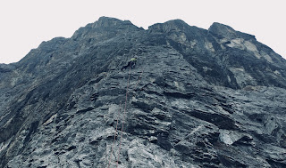
Jon Walsh scrambles up the slopes below the northeast buttress.

In the fourteen years since I first climbed the northeast buttress, I'd forgotten just how rank some of the rock on it is. Photo: Jon Walsh.

Jon Walsh enjoys the last bit of sun, with White Pyramid and Mt. Chephren behind...

... and traverses to the shady side of the buttress.

What shall it be? The northeast buttress on the left and the north face on the right.

Jon Walsh tiptoes up tricky mixed ground right off the belay.

"This is alpine climbing. Complicated work and never feeling solid." - Barry Blanchard, CAJ '88.

The setting sun lights up the summit of Mt. Chephren.

It could be a whole lot worse; home for the night. Photo: Jon Walsh.

The cozy confines of the tent.

Jon Walsh belays the first pitch of the second day from the tent platform.

Dry rock on the prow of the buttress... Photo: Jon Walsh.

... and rimed-up stone on its north side.

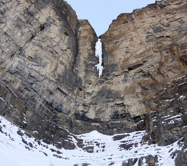
Jon Walsh starts up the M-16 gully on the upper east face...

... and comes to the last belay, with Chephren Lake far below.

Raphael Slawinski avoids harder climbing on the last pitch of the gully.

The obligatory goofy shot on a whited out summit.

The headwaters of the Howse River. My feet hurt just thinking about walking out that way!

Alpenglow on Howse Peak, with the descent route down the north glacier clearly visible.

Now that's what I call camping! The Epaulette-White Pyramid col is in the upper right corner of the photo. Hiking over the col and down the other side, it took us just over five hours from our camp to the road. Definitely the way to go!

Jon Walsh slogs up into the clouds.

The glacier on the east side of the col isn't as bad as it looks.

It's a long way down to Epaulette Lake. On the far side of the valley storm clouds envelop Mt. Murchison.

Fall colours on the valley bottom.

Jon Walsh fords the Mistaya River five minutes from the road.

shesh... I am always mesmerized by the routes you chose to climb and the pictures you take... :)
ReplyDeleteCongrats!